Arizona, located in the southwestern United States, is a state filled with diverse geography, rich cultural history, and natural beauty. A closer look at the Arizona map reveals more than just lines and cities—it opens a window into a land of deserts, mountains, forests, and historic landmarks. From the vibrant cityscape of Phoenix to the stunning Grand Canyon and the historic Route 66, Arizona’s map is a treasure trove for explorers, students, and travelers alike.
Geographic Overview of Arizona
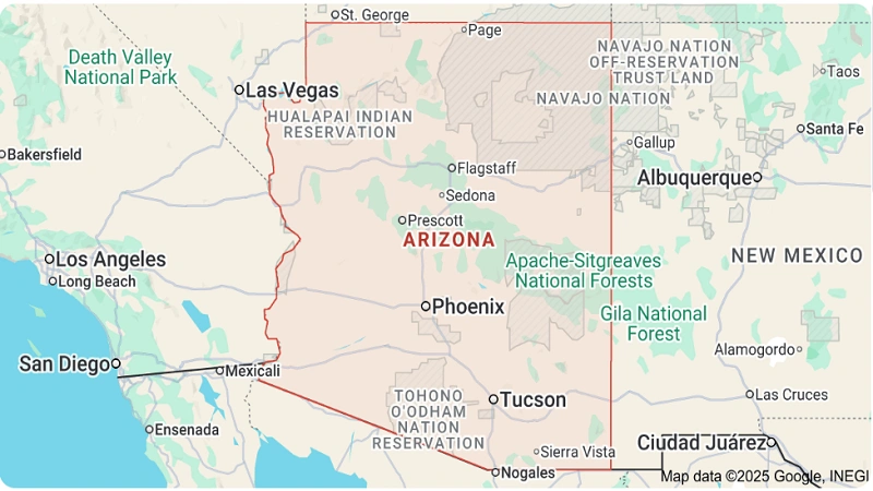
On the map, Arizona is bordered by California and Nevada to the west, Utah to the north, New Mexico to the east, and Mexico to the south. The state covers over 113,000 square miles, making it the sixth-largest in the U.S. Arizona is part of the Four Corners region, where it meets Colorado at a single point—a unique geographic landmark.
The map of Arizona is diverse in terrain. The northern part features high plateaus, pine forests, and snowy mountains, while the southern region is dominated by desert landscapes, especially the Sonoran Desert. This contrast makes Arizona’s geography both unique and varied, offering a wide range of climates and ecosystems.
Major Cities on the Arizona Map
The Arizona map highlights several major cities, each contributing to the state’s character and economy.
-
Phoenix: Located in central Arizona, Phoenix is the capital and the largest city. Known for its warm climate and modern urban development, it’s a major hub for business, education, and culture.
-
Tucson: Found in southern Arizona, Tucson is known for its strong Mexican-American influence, historic missions, and the University of Arizona. The city also serves as a gateway to desert and mountain exploration.
-
Flagstaff: Situated in the north, Flagstaff offers a cool contrast to the desert heat. It’s close to the San Francisco Peaks and serves as a base for visitors heading to the Grand Canyon.
-
Mesa, Chandler, and Scottsdale: These cities, part of the Phoenix metropolitan area, are growing rapidly and represent the state’s expanding suburban landscape.
Natural Landmarks Visible on the Arizona Map
One of the first features that stand out on the Arizona map is the Grand Canyon—one of the most iconic natural wonders in the world. Located in the northern part of the state, this massive gorge carved by the Colorado River stretches 277 miles in length and is a must-visit site for millions of tourists each year.
Other notable landmarks include:
-
Monument Valley: Located in the northeastern corner of the state, this area is known for its towering sandstone buttes and has served as the backdrop for countless films.
-
Saguaro National Park: Near Tucson, this park showcases the giant saguaro cactus and desert scenery.
-
Petrified Forest National Park: Found in northeastern Arizona, this park is home to fossilized trees, colorful badlands, and historic sites along Route 66.
Highways and Transportation Routes
Looking at an Arizona road map, several major highways and interstates stand out:
-
Interstate 10 (I-10) runs east-west through southern Arizona, connecting Phoenix and Tucson and extending to California and New Mexico.
-
Interstate 17 (I-17) links Phoenix with Flagstaff, providing access to northern attractions like Sedona and the Grand Canyon.
-
Route 66, the historic highway that once connected Chicago to Los Angeles, passes through northern Arizona and remains a nostalgic route for travelers.
These transportation networks are essential for commerce, tourism, and local travel, and are marked on most maps of Arizona.
Rivers and Lakes on the Arizona Map
Arizona may be known for its deserts, but it is also home to several significant rivers and man-made lakes.
-
Colorado River: This vital river defines the state’s western boundary and is responsible for carving the Grand Canyon. It also supplies water to millions of residents.
-
Salt River and Gila River flow through central and southern Arizona, playing important roles in irrigation and water supply.
-
Lake Powell, Lake Mead, and Roosevelt Lake are large reservoirs used for recreation and water storage. These bodies of water offer boating, fishing, and scenic beauty.
Cultural and Historical Markers
Maps of Arizona often include markers for Native American reservations, historic sites, and cultural centers. Arizona is home to 22 federally recognized tribes, including the Navajo Nation, Hopi Tribe, and Apache peoples. The Navajo Nation is the largest in the United States, and its lands are visible on detailed political or tribal maps.
Historical locations like Tombstone, the site of the famous gunfight at the O.K. Corral, and Jerome, an old mining town turned artist colony, are also popular attractions.
How to Use an Arizona Map
An Arizona map can be a practical tool for:
-
Trip planning: Identify driving routes, national parks, and cities.
-
Educational purposes: Learn about geography, natural resources, and historical sites.
-
Real estate and development: Study urban areas, transportation access, and land use.
-
Hiking and outdoor activities: Topographic maps help navigate trails, canyons, and forests.
Whether you’re exploring digitally via an interactive map or using a traditional paper one, Arizona maps offer valuable insights into the state’s layout and features.
Conclusion
The Arizona map is more than a geographic tool—it’s a visual representation of a dynamic and diverse state. With its blend of modern cities, ancient landscapes, desert wonders, and vibrant communities, Arizona invites discovery at every corner. Whether you’re planning a trip, studying the region, or just exploring from your screen, the map of Arizona will guide you through one of the most remarkable regions in the United States.